Thank you for supporting this site ❤️
Make a donation
Make a donation
Gear up for your next adventure:
As an Amazon Associate, this site earns from qualifying purchases at no extra cost to you.
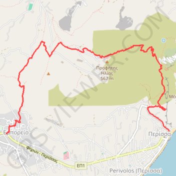
Profitis Ilias de Santorin
- Distance: 4.8 mi
- Elevation gain: 533 m
- Maximum elevation: 550 m
- Elevation loss: 608 m
- Minimum elevation: -1 m
Interactive trail map
Thank you for supporting this site ❤️
Make a donation
Make a donation
Gear up for your next adventure:
As an Amazon Associate, this site earns from qualifying purchases at no extra cost to you.
Trail profile
- Distance: 4.8 mi
- Elevation gain: 533 m
- Maximum elevation: 550 m
- Elevation loss: 608 m
- Minimum elevation: -1 m
Thank you for supporting this site ❤️
Make a donation
Make a donation
Gear up for your next adventure:
As an Amazon Associate, this site earns from qualifying purchases at no extra cost to you.
About this trail
Name: Profitis Ilias de Santorin trail, distance, elevation, map, profile, GPS track
Coordinates: 36.35681 25.44433 36.37114 25.47574
Thank you for supporting this site ❤️
Make a donation
Make a donation
Gear up for your next adventure:
As an Amazon Associate, this site earns from qualifying purchases at no extra cost to you.