Thank you for supporting this site ❤️
Make a donation
Make a donation
Gear up for your next adventure:
As an Amazon Associate, this site earns from qualifying purchases at no extra cost to you.
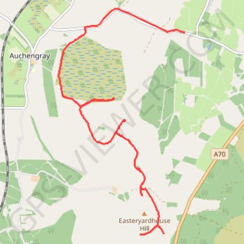
Wind farm walk
- Distance: 5.7 mi
- Elevation gain: 99 m
- Maximum elevation: 282 m
- Elevation loss: 90 m
- Minimum elevation: 257 m
- Moving time: 1 h 29 m
- Moving speed: 3.8 mph
- Maximum speed: 38.9 mph
- Total time: 1 h 38 m
- Global speed: 3.5 mph
Interactive trail map
Thank you for supporting this site ❤️
Make a donation
Make a donation
Gear up for your next adventure:
As an Amazon Associate, this site earns from qualifying purchases at no extra cost to you.
Trail profile
- Distance: 5.7 mi
- Elevation gain: 99 m
- Maximum elevation: 282 m
- Elevation loss: 90 m
- Minimum elevation: 257 m
- Moving time: 1 h 29 m
- Moving speed: 3.8 mph
- Maximum speed: 38.9 mph
- Total time: 1 h 38 m
- Global speed: 3.5 mph
Thank you for supporting this site ❤️
Make a donation
Make a donation
Gear up for your next adventure:
As an Amazon Associate, this site earns from qualifying purchases at no extra cost to you.
About this trail
Name: Wind farm walk trail, distance, elevation, map, profile, GPS track
Start: A70, Bertram House, South Lanarkshire, Scotland, ML11 8LG, United Kingdom (55.74415 -3.57368)
End: Polkelly, Auchengray, South Lanarkshire, Scotland, EH55 8LN, United Kingdom (55.77397 -3.56200)
Coordinates: 55.74415 -3.59499 55.77739 -3.56200
Topography: South Lanarkshire topographic map, elevation, terrain
Thank you for supporting this site ❤️
Make a donation
Make a donation
Gear up for your next adventure:
As an Amazon Associate, this site earns from qualifying purchases at no extra cost to you.