Import a GPX file

East Coast Trail - Father Troy Path

#Hiking #Newfoundland #Atlantic

  • Distance: 4.5 mi
  • Elevation gain: 283 m
  • Maximum elevation: 125 m
  • Elevation loss: 278 m
  • Minimum elevation: 0 m

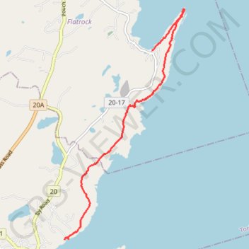
Interactive trail map

Trail profile

  • Distance: 4.5 mi
  • Elevation gain: 283 m
  • Maximum elevation: 125 m
  • Elevation loss: 278 m
  • Minimum elevation: 0 m

About this trail

Name: East Coast Trail - Father Troy Path trail, distance, elevation, map, profile, GPS track

Start: East Coast Trail, Flatrock, Newfoundland, Newfoundland and Labrador, A1K 1C9, Canada (47.69959 -52.70374)

End: Tappers Cove Road, Torbay, Newfoundland, Newfoundland and Labrador, A1K 1B3, Canada (47.66532 -52.72737)

Coordinates: 47.66532 -52.72737 47.70710 -52.69504

Other hiking, mountain biking, running and outdoor activity trails

Click on a trail to view its statistics, map and profile.

East Coast Trail - Stiles Cove Path

Canada > Newfoundland and Labrador > Flatrock

#Hiking #Newfoundland #Atlantic

Distance: 9.9 mi • Elevation gain: 882 m • Maximum elevation: 101 m

Gear up for your next adventure:

🪢Paracord - Multi-purpose cord for camping and survival
🧥Packable Down Jackets - Lightweight warmth that compresses small in your bag
🧭Professional Hiking Compasses - High-precision liquid-filled compasses for map reading and orientation
📚UK Hiking Guidebooks - Detailed route descriptions for the Lake District, Peaks, and Highlands
🗺️Scratch-off Peak Maps - Track your progress climbing Munros or Wainwrights

As an Amazon Associate, this site earns from qualifying purchases at no extra cost to you.