Thank you for supporting this site ❤️
Make a donation
Make a donation
Gear up for your next adventure:
As an Amazon Associate, this site earns from qualifying purchases at no extra cost to you.
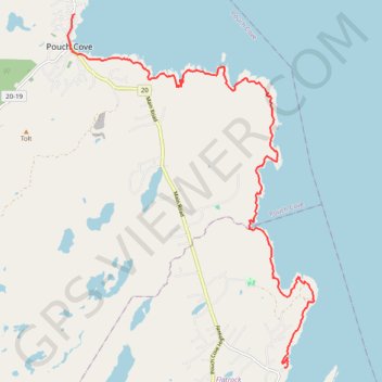
East Coast Trail - Stiles Cove Path
#Hiking #Newfoundland #Atlantic
- Distance: 9.9 mi
- Elevation gain: 882 m
- Maximum elevation: 101 m
- Elevation loss: 880 m
- Minimum elevation: 0 m
Interactive trail map
Thank you for supporting this site ❤️
Make a donation
Make a donation
Gear up for your next adventure:
As an Amazon Associate, this site earns from qualifying purchases at no extra cost to you.
Trail profile
- Distance: 9.9 mi
- Elevation gain: 882 m
- Maximum elevation: 101 m
- Elevation loss: 880 m
- Minimum elevation: 0 m
Thank you for supporting this site ❤️
Make a donation
Make a donation
Gear up for your next adventure:
As an Amazon Associate, this site earns from qualifying purchases at no extra cost to you.
About this trail
Name: East Coast Trail - Stiles Cove Path trail, distance, elevation, map, profile, GPS track
Coordinates: 47.70692 -52.76554 47.76943 -52.70075
Thank you for supporting this site ❤️
Make a donation
Make a donation
Gear up for your next adventure:
As an Amazon Associate, this site earns from qualifying purchases at no extra cost to you.
Other hiking, mountain biking, running and outdoor activity trails
Click on a trail to view its statistics, map and profile.
East Coast Trail - Father Troy Path
Canada > Newfoundland and Labrador > Flatrock
#Hiking #Newfoundland #Atlantic
Distance: 4.5 mi • Elevation gain: 283 m • Maximum elevation: 125 m