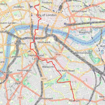
Green Link Walk from Smithfield Market to end at Pekham
- Distance: 5.4 mi
- Elevation gain: 41 m
- Maximum elevation: 34 m
- Elevation loss: 56 m
- Minimum elevation: 2 m
- Moving time: 1 h 40 m
- Moving speed: 3.2 mph
- Maximum speed: 7.1 mph
- Total time: 1 h 49 m
- Global speed: 3.0 mph
Interactive trail map
Trail profile
- Distance: 5.4 mi
- Elevation gain: 41 m
- Maximum elevation: 34 m
- Elevation loss: 56 m
- Minimum elevation: 2 m
- Moving time: 1 h 40 m
- Moving speed: 3.2 mph
- Maximum speed: 7.1 mph
- Total time: 1 h 49 m
- Global speed: 3.0 mph
About this trail
Name: Green Link Walk from Smithfield Market to end at Pekham trail, distance, elevation, map, profile, GPS track
Coordinates: 51.47330 -0.10454 51.52104 -0.06963
Topography: City of London topographic map, elevation, terrain
Other hiking, mountain biking, running and outdoor activity trails
Click on a trail to view its statistics, map and profile.
Burgess Park
United Kingdom > England > Greater London
Distance: 3.3 mi • Elevation gain: 16 m • Maximum elevation: 6 m
Northern Section of Green Link Walk from Epping Forest to Smithfield Market
United Kingdom > England > London
Distance: 10.9 mi • Elevation gain: 71 m • Maximum elevation: 46 m
2014-07-29 06:09:07 Auto
United Kingdom > England > London
Distance: 37.8 mi • Elevation gain: 307 m • Maximum elevation: 38 m
London Marathon
United Kingdom > England > London
Distance: 26.2 mi • Elevation gain: 281 m • Maximum elevation: 50 m