Make a donation
Gear up for your next adventure:
As an Amazon Associate, this site earns from qualifying purchases at no extra cost to you.
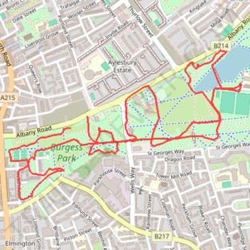
Burgess Park
- Distance: 3.3 mi
- Elevation gain: 16 m
- Maximum elevation: 6 m
- Elevation loss: 17 m
- Minimum elevation: 1 m
- Moving time: 41 m 39 s
- Moving speed: 4.8 mph
- Maximum speed: 9.6 mph
- Total time: 41 m 39 s
- Global speed: 4.8 mph
Interactive trail map
Make a donation
Gear up for your next adventure:
As an Amazon Associate, this site earns from qualifying purchases at no extra cost to you.
Trail profile
- Distance: 3.3 mi
- Elevation gain: 16 m
- Maximum elevation: 6 m
- Elevation loss: 17 m
- Minimum elevation: 1 m
- Moving time: 41 m 39 s
- Moving speed: 4.8 mph
- Maximum speed: 9.6 mph
- Total time: 41 m 39 s
- Global speed: 4.8 mph
Make a donation
Gear up for your next adventure:
As an Amazon Associate, this site earns from qualifying purchases at no extra cost to you.
About this trail
Name: Burgess Park trail, distance, elevation, map, profile, GPS track
Coordinates: 51.47956 -0.09386 51.48599 -0.07785
Topography: Greater London topographic map, elevation, terrain
Make a donation
Gear up for your next adventure:
As an Amazon Associate, this site earns from qualifying purchases at no extra cost to you.
Other hiking, mountain biking, running and outdoor activity trails
Click on a trail to view its statistics, map and profile.
Green Link Walk from Smithfield Market to end at Pekham
United Kingdom > England > City of London
Distance: 5.4 mi • Elevation gain: 41 m • Maximum elevation: 34 m
London Marathon
United Kingdom > England > London
Distance: 26.2 mi • Elevation gain: 281 m • Maximum elevation: 50 m
2014-07-29 06:09:07 Auto
United Kingdom > England > London
Distance: 37.8 mi • Elevation gain: 307 m • Maximum elevation: 38 m