Make a donation
Gear up for your next adventure:
As an Amazon Associate, this site earns from qualifying purchases at no extra cost to you.
One last leg of the Bruce Trail after checkout
- Distance: 2.8 mi
- Elevation gain: 67 m
- Maximum elevation: 417 m
- Elevation loss: 47 m
- Minimum elevation: 382 m
Interactive trail map
Make a donation
Gear up for your next adventure:
As an Amazon Associate, this site earns from qualifying purchases at no extra cost to you.
Trail profile
- Distance: 2.8 mi
- Elevation gain: 67 m
- Maximum elevation: 417 m
- Elevation loss: 47 m
- Minimum elevation: 382 m
Make a donation
Gear up for your next adventure:
As an Amazon Associate, this site earns from qualifying purchases at no extra cost to you.
About this trail
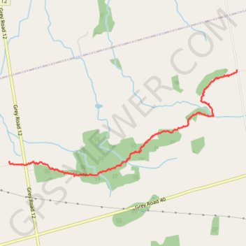
Name: One last leg of the Bruce Trail after checkout trail, distance, elevation, map, profile, GPS track
Start: Bruce Trail - Sydenham, Grey Highlands, Grey County, Ontario, Canada (44.50098 -80.63553)
End: 156885, 7th Line, Grey Highlands, Grey County, Ontario, Canada (44.51095 -80.60069)
Coordinates: 44.49931 -80.63553 44.51095 -80.60066
Make a donation
Gear up for your next adventure:
As an Amazon Associate, this site earns from qualifying purchases at no extra cost to you.
Other hiking, mountain biking, running and outdoor activity trails
Click on a trail to view its statistics, map and profile.
Owen Sound - Orangeville
Canada > Ontario > Grey County > Owen Sound
Distance: 66.9 mi • Elevation gain: 593 m • Maximum elevation: 517 m
Owen Sound - Wasaga Beach
Canada > Ontario > Grey County > Owen Sound
Lake Huron. Georgian Bay. #Bike #Lake #Countryside #Town #Nature
Distance: 48.3 mi • Elevation gain: 320 m • Maximum elevation: 351 m