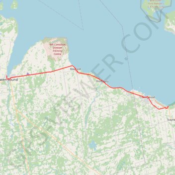
Owen Sound - Wasaga Beach
Lake Huron. Georgian Bay. #Bike #Lake #Countryside #Town #Nature
- Distance: 48.3 mi
- Elevation gain: 320 m
- Maximum elevation: 351 m
- Elevation loss: 315 m
- Minimum elevation: 177 m
Interactive trail map
Trail profile
- Distance: 48.3 mi
- Elevation gain: 320 m
- Maximum elevation: 351 m
- Elevation loss: 315 m
- Minimum elevation: 177 m
About this trail
Name: Owen Sound - Wasaga Beach trail, distance, elevation, map, profile, GPS track
Coordinates: 44.45674 -80.94698 44.61884 -80.10737
Other hiking, mountain biking, running and outdoor activity trails
Click on a trail to view its statistics, map and profile.
Owen Sound - Orangeville
Canada > Ontario > Grey County > Owen Sound
Distance: 66.9 mi • Elevation gain: 593 m • Maximum elevation: 517 m
Wasaga Beach - Orillia
Canada > Ontario > Simcoe County > Wasaga Beach
Distance: 50.5 mi • Elevation gain: 450 m • Maximum elevation: 343 m
One last leg of the Bruce Trail after checkout
Canada > Ontario > Grey County > Grey Highlands
Distance: 2.8 mi • Elevation gain: 67 m • Maximum elevation: 417 m