Thank you for supporting this site ❤️
Make a donation
Make a donation
Gear up for your next adventure:
As an Amazon Associate, this site earns from qualifying purchases at no extra cost to you.
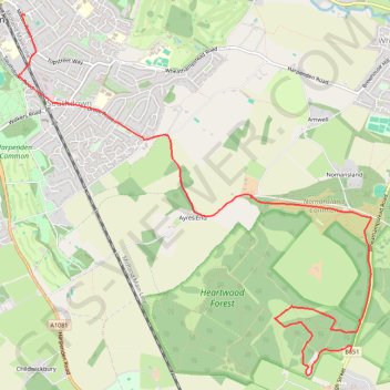
Heartwood Forest
- Distance: 5.5 mi
- Elevation gain: 108 m
- Maximum elevation: 127 m
- Elevation loss: 68 m
- Minimum elevation: 86 m
- Moving time: 43 m 55 s
- Moving speed: 7.5 mph
- Maximum speed: 21.3 mph
- Total time: 47 m 17 s
- Global speed: 7.0 mph
Interactive trail map
Thank you for supporting this site ❤️
Make a donation
Make a donation
Gear up for your next adventure:
As an Amazon Associate, this site earns from qualifying purchases at no extra cost to you.
Trail profile
- Distance: 5.5 mi
- Elevation gain: 108 m
- Maximum elevation: 127 m
- Elevation loss: 68 m
- Minimum elevation: 86 m
- Moving time: 43 m 55 s
- Moving speed: 7.5 mph
- Maximum speed: 21.3 mph
- Total time: 47 m 17 s
- Global speed: 7.0 mph
Thank you for supporting this site ❤️
Make a donation
Make a donation
Gear up for your next adventure:
As an Amazon Associate, this site earns from qualifying purchases at no extra cost to you.
About this trail
Name: Heartwood Forest trail, distance, elevation, map, profile, GPS track
Coordinates: 51.78312 -0.34944 51.81488 -0.29927
Topography: St Albans topographic map, elevation, terrain
Thank you for supporting this site ❤️
Make a donation
Make a donation
Gear up for your next adventure:
As an Amazon Associate, this site earns from qualifying purchases at no extra cost to you.
Other hiking, mountain biking, running and outdoor activity trails
Click on a trail to view its statistics, map and profile.
Ponds in Harpenden
United Kingdom > England > Hertfordshire > St Albans > Harpenden > Hatching Green
Distance: 0.4 mi • Elevation gain: 4 m • Maximum elevation: 106 m