Thank you for supporting this site ❤️
Make a donation
Make a donation
Gear up for your next adventure:
As an Amazon Associate, this site earns from qualifying purchases at no extra cost to you.
Ponds in Harpenden
- Distance: 0.4 mi
- Elevation gain: 4 m
- Maximum elevation: 106 m
- Elevation loss: 4 m
- Minimum elevation: 102 m
- Moving time: 10 m 41 s
- Moving speed: 2.4 mph
- Maximum speed: 4.4 mph
- Total time: 13 m 44 s
- Global speed: 1.9 mph
Interactive trail map
Thank you for supporting this site ❤️
Make a donation
Make a donation
Gear up for your next adventure:
As an Amazon Associate, this site earns from qualifying purchases at no extra cost to you.
Trail profile
- Distance: 0.4 mi
- Elevation gain: 4 m
- Maximum elevation: 106 m
- Elevation loss: 4 m
- Minimum elevation: 102 m
- Moving time: 10 m 41 s
- Moving speed: 2.4 mph
- Maximum speed: 4.4 mph
- Total time: 13 m 44 s
- Global speed: 1.9 mph
Thank you for supporting this site ❤️
Make a donation
Make a donation
Gear up for your next adventure:
As an Amazon Associate, this site earns from qualifying purchases at no extra cost to you.
About this trail
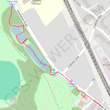
Name: Ponds in Harpenden trail, distance, elevation, map, profile, GPS track
Coordinates: 51.80848 -0.35210 51.81162 -0.34753
Topography: St Albans topographic map, elevation, terrain
Thank you for supporting this site ❤️
Make a donation
Make a donation
Gear up for your next adventure:
As an Amazon Associate, this site earns from qualifying purchases at no extra cost to you.
Other hiking, mountain biking, running and outdoor activity trails
Click on a trail to view its statistics, map and profile.
Heartwood Forest
United Kingdom > England > Hertfordshire > St Albans > Sandridge
Distance: 5.5 mi • Elevation gain: 108 m • Maximum elevation: 127 m