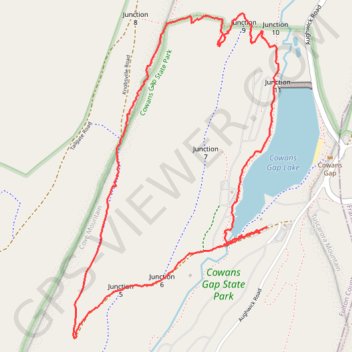
Cowans Gap Loop Trail via Cowans Gap Lake, Standing Stone Trail and Cove Mountain
The Cowans Gap Loop Trail offers a dynamic hiking experience that combines serene lakeside views, challenging mountain ascents, and rewarding vistas. Starting at Cowans Gap Lake, the easy Lakeside Trail gives a peaceful introduction with scenic views of the lake and opportunities for wildlife spotting. As you transition onto the Standing Stone Trail, the hike becomes more intense, climbing up Cove Mountain and leading to breathtaking overlooks, like Knobsville Vista, where you can admire sweeping views of the surrounding valleys. The diversity of landscapes along the trail makes it a fantastic day hike for those looking for both tranquility and adventure in Cowans Gap State Park. #Hiking #Loop #Lake #Mountain #Nature #Forest
- Distance: 3.8 mi
- Elevation gain: 263 m
- Maximum elevation: 586 m
- Elevation loss: 262 m
- Minimum elevation: 370 m
- Moving time: 1 h 20 m
- Moving speed: 2.9 mph
- Maximum speed: 21.0 mph
- Total time: 2 h 28 m
- Global speed: 1.6 mph
Interactive trail map
Trail profile
- Distance: 3.8 mi
- Elevation gain: 263 m
- Maximum elevation: 586 m
- Elevation loss: 262 m
- Minimum elevation: 370 m
- Moving time: 1 h 20 m
- Moving speed: 2.9 mph
- Maximum speed: 21.0 mph
- Total time: 2 h 28 m
- Global speed: 1.6 mph
About this trail
Name: Cowans Gap Loop Trail via Cowans Gap Lake, Standing Stone Trail and Cove Mountain trail, distance, elevation, map, profile, GPS track
Coordinates: 39.98937 -77.93823 40.00540 -77.92504
Other hiking, mountain biking, running and outdoor activity trails
Click on a trail to view its statistics, map and profile.
Cowans Gap State Park Loop
United States > Pennsylvania > Fulton County > Todd Township
Distance: 4.0 mi • Elevation gain: 257 m • Maximum elevation: 609 m
Cowans Gap Lake Loop
United States > Pennsylvania > Fulton County > Todd Township
Lakeside Trail
Distance: 1.4 mi • Elevation gain: 47 m • Maximum elevation: 386 m