Cowans Gap State Park Loop
- Distance: 4.0 mi
- Elevation gain: 257 m
- Maximum elevation: 609 m
- Elevation loss: 256 m
- Minimum elevation: 372 m
- Moving time: 2 h 13 m
- Moving speed: 1.8 mph
- Maximum speed: 4.5 mph
- Total time: 3 h 53 m
- Global speed: 1.0 mph
Interactive trail map
Trail profile
- Distance: 4.0 mi
- Elevation gain: 257 m
- Maximum elevation: 609 m
- Elevation loss: 256 m
- Minimum elevation: 372 m
- Moving time: 2 h 13 m
- Moving speed: 1.8 mph
- Maximum speed: 4.5 mph
- Total time: 3 h 53 m
- Global speed: 1.0 mph
About this trail
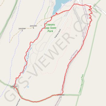
Name: Cowans Gap State Park Loop trail, distance, elevation, map, profile, GPS track
Coordinates: 39.97867 -77.93720 39.99634 -77.91870
Other hiking, mountain biking, running and outdoor activity trails
Click on a trail to view its statistics, map and profile.
Cowans Gap Loop Trail via Cowans Gap Lake, Standing Stone Trail and Cove Mountain
United States > Pennsylvania > Fulton County > Todd Township
The Cowans Gap Loop Trail offers a dynamic hiking experience that combines serene lakeside views, challenging mountain ascents, and rewarding vistas. Starting at Cowans Gap Lake, the easy Lakeside Trail gives a peaceful introduction with scenic views of the lake and opportunities for wildlife spotting. As you…
Distance: 3.8 mi • Elevation gain: 263 m • Maximum elevation: 586 m
Cowans Gap Lake Loop
United States > Pennsylvania > Fulton County > Todd Township
Lakeside Trail
Distance: 1.4 mi • Elevation gain: 47 m • Maximum elevation: 386 m