Thank you for supporting this site ❤️
Make a donation
Make a donation
Gear up for your next adventure:
As an Amazon Associate, this site earns from qualifying purchases at no extra cost to you.
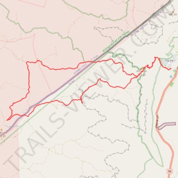
ריצת מדבר מעין גדי להר חולד
- Distance: 19.7 mi
- Elevation gain: 1,160 m
- Maximum elevation: 474 m
- Elevation loss: 1,159 m
- Minimum elevation: -351 m
- Moving time: 5 h 27 m
- Moving speed: 3.6 mph
- Maximum speed: 8.0 mph
- Total time: 5 h 46 m
- Global speed: 3.4 mph
Interactive trail map
Thank you for supporting this site ❤️
Make a donation
Make a donation
Gear up for your next adventure:
As an Amazon Associate, this site earns from qualifying purchases at no extra cost to you.
Trail profile
- Distance: 19.7 mi
- Elevation gain: 1,160 m
- Maximum elevation: 474 m
- Elevation loss: 1,159 m
- Minimum elevation: -351 m
- Moving time: 5 h 27 m
- Moving speed: 3.6 mph
- Maximum speed: 8.0 mph
- Total time: 5 h 46 m
- Global speed: 3.4 mph
Thank you for supporting this site ❤️
Make a donation
Make a donation
Gear up for your next adventure:
As an Amazon Associate, this site earns from qualifying purchases at no extra cost to you.
About this trail
Name: ריצת מדבר מעין גדי להר חולד trail, distance, elevation, map, profile, GPS track
Coordinates: 31.42122 35.28647 31.45392 35.38613
Thank you for supporting this site ❤️
Make a donation
Make a donation
Gear up for your next adventure:
As an Amazon Associate, this site earns from qualifying purchases at no extra cost to you.
Other hiking, mountain biking, running and outdoor activity trails
Click on a trail to view its statistics, map and profile.
Ein Gedi - Mishmar
Israel > South District > Tamar Regional Council > Ein Gedi
עין גדי לנחל משמר: קו זורם על במת מדבר יהודה וביקור בעין חבר
Distance: 11.6 mi • Elevation gain: 827 m • Maximum elevation: 275 m