Prior Park, Combe Down, Allotments
- Distance: 4.0 mi
- Elevation gain: 148 m
- Maximum elevation: 163 m
- Elevation loss: 167 m
- Minimum elevation: 46 m
- Moving time: 1 h 45 m
- Moving speed: 2.3 mph
- Maximum speed: 6.0 mph
- Total time: 2 h 33 m
- Global speed: 1.6 mph
Interactive trail map
Trail profile
- Distance: 4.0 mi
- Elevation gain: 148 m
- Maximum elevation: 163 m
- Elevation loss: 167 m
- Minimum elevation: 46 m
- Moving time: 1 h 45 m
- Moving speed: 2.3 mph
- Maximum speed: 6.0 mph
- Total time: 2 h 33 m
- Global speed: 1.6 mph
About this trail
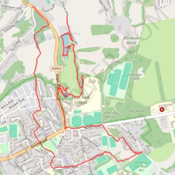
Name: Prior Park, Combe Down, Allotments trail, distance, elevation, map, profile, GPS track
Coordinates: 51.35927 -2.34927 51.37246 -2.33486
Topography: Bath topographic map, elevation, terrain
Other hiking, mountain biking, running and outdoor activity trails
Click on a trail to view its statistics, map and profile.
Mulberry Park
United Kingdom > England > Bath and North East Somerset > Bath
Distance: 1.3 mi • Elevation gain: 36 m • Maximum elevation: 160 m