Thank you for supporting this site ❤️
Make a donation
Make a donation
Gear up for your next adventure:
As an Amazon Associate, this site earns from qualifying purchases at no extra cost to you.
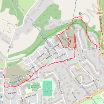
Mulberry Park
- Distance: 1.3 mi
- Elevation gain: 36 m
- Maximum elevation: 160 m
- Elevation loss: 18 m
- Minimum elevation: 135 m
- Moving time: 37 m 26 s
- Moving speed: 2.1 mph
- Maximum speed: 10.7 mph
- Total time: 44 m 8 s
- Global speed: 1.8 mph
Interactive trail map
Thank you for supporting this site ❤️
Make a donation
Make a donation
Gear up for your next adventure:
As an Amazon Associate, this site earns from qualifying purchases at no extra cost to you.
Trail profile
- Distance: 1.3 mi
- Elevation gain: 36 m
- Maximum elevation: 160 m
- Elevation loss: 18 m
- Minimum elevation: 135 m
- Moving time: 37 m 26 s
- Moving speed: 2.1 mph
- Maximum speed: 10.7 mph
- Total time: 44 m 8 s
- Global speed: 1.8 mph
Thank you for supporting this site ❤️
Make a donation
Make a donation
Gear up for your next adventure:
As an Amazon Associate, this site earns from qualifying purchases at no extra cost to you.
About this trail
Name: Mulberry Park trail, distance, elevation, map, profile, GPS track
Coordinates: 51.36243 -2.35644 51.36719 -2.34603
Topography: Bath topographic map, elevation, terrain
Thank you for supporting this site ❤️
Make a donation
Make a donation
Gear up for your next adventure:
As an Amazon Associate, this site earns from qualifying purchases at no extra cost to you.
Other hiking, mountain biking, running and outdoor activity trails
Click on a trail to view its statistics, map and profile.
Prior Park, Combe Down, Allotments
United Kingdom > England > Bath and North East Somerset > Bath
Distance: 4.0 mi • Elevation gain: 148 m • Maximum elevation: 163 m