Import a GPX file

Marina Parade -> Haji Lane

  • Distance: 5.8 mi
  • Elevation gain: 47 m
  • Maximum elevation: 19 m
  • Elevation loss: 49 m
  • Minimum elevation: 6 m

Interactive trail map

Trail profile

  • Distance: 5.8 mi
  • Elevation gain: 47 m
  • Maximum elevation: 19 m
  • Elevation loss: 49 m
  • Minimum elevation: 6 m

About this trail

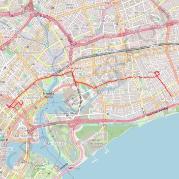
Name: Marina Parade -> Haji Lane trail, distance, elevation, map, profile, GPS track

Start: 74, Marine Parade Central, Marine Drive Gardens, Marine Parade, Southeast, Singapore, 440074, Singapore (1.30351 103.90691)

End: 61, Bussorah Street, Rochor, Central, Singapore, 199471, Singapore (1.30160 103.85962)

Coordinates: 1.29984 103.85464 1.31141 103.90691

Other hiking, mountain biking, running and outdoor activity trails

Click on a trail to view its statistics, map and profile.

Singapore East Coast Park

Singapore > Singapore

#Hiking

Distance: 7.8 mi • Elevation gain: 79 m • Maximum elevation: 22 m

Singapore

Singapore > Singapore

#Hiking

Distance: 8.9 mi • Elevation gain: 214 m • Maximum elevation: 49 m

Directions from Duck Tour Ramp to Marina Boulevard, Singapore

Singapore > Singapore

Distance: 65.5 mi • Elevation gain: 812 m • Maximum elevation: 51 m

Morning Run

Singapore > Singapore

Distance: 8.4 mi • Elevation gain: 166 m • Maximum elevation: 21 m

Gear up for your next adventure:

🥤Hydration Bladders - Hands-free hydration systems for backpacks
🥄Titanium Camping Sporks - The ultimate lightweight utensil for trail meals
🎒Hiking Daypacks (20L) - Compact backpacks for day trips and technical mountain ascents
🧗Locking Carabiners - Secure gear to your pack or for light technical use
🔦Outdoor Torches - Reliable torches for night navigation

As an Amazon Associate, this site earns from qualifying purchases at no extra cost to you.