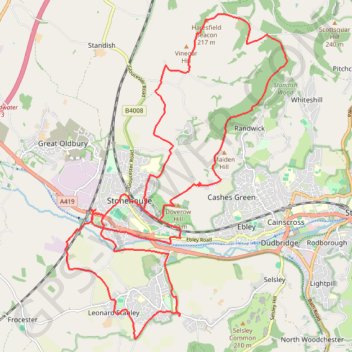
Stroud-Haresfield
- Distance: 16.4 mi
- Elevation gain: 430 m
- Maximum elevation: 246 m
- Elevation loss: 428 m
- Minimum elevation: 22 m
- Moving time: 5 h 42 m
- Moving speed: 2.9 mph
- Maximum speed: 6.7 mph
- Total time: 7 h 31 m
- Global speed: 2.2 mph
Interactive trail map
Trail profile
- Distance: 16.4 mi
- Elevation gain: 430 m
- Maximum elevation: 246 m
- Elevation loss: 428 m
- Minimum elevation: 22 m
- Moving time: 5 h 42 m
- Moving speed: 2.9 mph
- Maximum speed: 6.7 mph
- Total time: 7 h 31 m
- Global speed: 2.2 mph
About this trail
Name: Stroud-Haresfield trail, distance, elevation, map, profile, GPS track
Coordinates: 51.72364 -2.30084 51.77942 -2.23930
Topography: Gloucestershire topographic map, elevation, terrain
Other hiking, mountain biking, running and outdoor activity trails
Click on a trail to view its statistics, map and profile.
Five Valleys Loop Walk
United Kingdom > England > Gloucestershire > Stroud > Randwick
Distance: 21.3 mi • Elevation gain: 907 m • Maximum elevation: 253 m
Stonehouse to Frampton
United Kingdom > England > Gloucestershire > Stonehouse
Distance: 11.3 mi • Elevation gain: 88 m • Maximum elevation: 37 m
Standish Wood Loop Hike
United Kingdom > England > Gloucestershire > Stroud > Whiteshill
Distance: 6.9 mi • Elevation gain: 253 m • Maximum elevation: 253 m
Woodchester Stroud Walking
United Kingdom > England > Gloucestershire > Nailsworth > Box
Distance: 14.1 mi • Elevation gain: 491 m • Maximum elevation: 211 m
NW to Stroud
United Kingdom > England > Gloucestershire > Nailsworth > Inchbrook
Stroud Walking
Distance: 11.9 mi • Elevation gain: 451 m • Maximum elevation: 200 m
Dean2023-311
United Kingdom > England > Oxfordshire > Oxford
Distance: 192.8 mi • Elevation gain: 3,366 m • Maximum elevation: 290 m
Stroud North loop
United Kingdom > England > Gloucestershire > Stroud > Selsley
Distance: 9.0 mi • Elevation gain: 349 m • Maximum elevation: 223 m
Stroud direct
United Kingdom > England > Gloucestershire > Nailsworth > Box
Distance: 10.0 mi • Elevation gain: 301 m • Maximum elevation: 205 m
Five Valleys
United Kingdom > England > Gloucestershire > Stonehouse > Leonard Stanley
Distance: 23.7 mi • Elevation gain: 882 m • Maximum elevation: 253 m