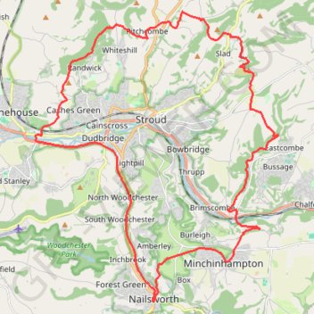
Five Valleys Loop Walk
- Distance: 21.3 mi
- Elevation gain: 907 m
- Maximum elevation: 253 m
- Elevation loss: 907 m
- Minimum elevation: 27 m
- Moving time: 6 h 48 m
- Moving speed: 3.1 mph
- Maximum speed: 8.1 mph
- Total time: 8 h 31 m
- Global speed: 2.5 mph
Interactive trail map
Trail profile
- Distance: 21.3 mi
- Elevation gain: 907 m
- Maximum elevation: 253 m
- Elevation loss: 907 m
- Minimum elevation: 27 m
- Moving time: 6 h 48 m
- Moving speed: 3.1 mph
- Maximum speed: 8.1 mph
- Total time: 8 h 31 m
- Global speed: 2.5 mph
About this trail
Name: Five Valleys Loop Walk trail, distance, elevation, map, profile, GPS track
Coordinates: 51.69437 -2.27192 51.77540 -2.16223
Topography: Gloucestershire topographic map, elevation, terrain
Other hiking, mountain biking, running and outdoor activity trails
Click on a trail to view its statistics, map and profile.
Laurie Lee Wildlife Way
United Kingdom > England > Gloucestershire > Painswick > Ham Butts
Distance: 9.3 mi • Elevation gain: 510 m • Maximum elevation: 215 m
Stroud trigs
United Kingdom > England > Gloucestershire > Stroud > Rodborough
Distance: 11.6 mi • Elevation gain: 526 m • Maximum elevation: 270 m
Woodchester Stroud Walking
United Kingdom > England > Gloucestershire > Nailsworth > Box
Distance: 14.1 mi • Elevation gain: 491 m • Maximum elevation: 211 m
Standish Wood Loop Hike
United Kingdom > England > Gloucestershire > Stroud > Whiteshill
Distance: 6.9 mi • Elevation gain: 253 m • Maximum elevation: 253 m
NW to Stroud
United Kingdom > England > Gloucestershire > Nailsworth > Inchbrook
Stroud Walking
Distance: 11.9 mi • Elevation gain: 451 m • Maximum elevation: 200 m
Loop walk from Nailsworth to Kingscote
United Kingdom > England > Gloucestershire > Nailsworth > Box
Distance: 7.6 mi • Elevation gain: 295 m • Maximum elevation: 213 m
Toadsmoor Valley
United Kingdom > England > Gloucestershire > Nailsworth > Box
Distance: 19.5 mi • Elevation gain: 839 m • Maximum elevation: 236 m
Nailsworth to Cherington loop
United Kingdom > England > Gloucestershire > Nailsworth > Box
Distance: 11.3 mi • Elevation gain: 403 m • Maximum elevation: 191 m
Nailsworth to Kingscote Loop
United Kingdom > England > Gloucestershire > Nailsworth > Inchbrook
Distance: 7.2 mi • Elevation gain: 273 m • Maximum elevation: 213 m
Nailsworth - Brimscombe
United Kingdom > England > Gloucestershire > Nailsworth > Box
Distance: 6.4 mi • Elevation gain: 322 m • Maximum elevation: 205 m
Painswick east loop
United Kingdom > England > Gloucestershire > Painswick > Ham Butts
Distance: 8.1 mi • Elevation gain: 484 m • Maximum elevation: 215 m
Minchinhampton loop
United Kingdom > England > Gloucestershire > Nailsworth > Box
Distance: 13.1 mi • Elevation gain: 414 m • Maximum elevation: 205 m
Stroud direct
United Kingdom > England > Gloucestershire > Nailsworth > Box
Distance: 10.0 mi • Elevation gain: 301 m • Maximum elevation: 205 m
Stroud-Haresfield
United Kingdom > England > Gloucestershire > Stonehouse
Distance: 16.4 mi • Elevation gain: 430 m • Maximum elevation: 246 m
Gatcombe Park
United Kingdom > England > Gloucestershire > Nailsworth > Box
Distance: 13.4 mi • Elevation gain: 452 m • Maximum elevation: 194 m
Avening loop
United Kingdom > England > Gloucestershire > Nailsworth > Box
Distance: 11.0 mi • Elevation gain: 329 m • Maximum elevation: 186 m
Dean2023-311
United Kingdom > England > Oxfordshire > Oxford
Distance: 192.8 mi • Elevation gain: 3,366 m • Maximum elevation: 290 m
Stroud North loop
United Kingdom > England > Gloucestershire > Stroud > Selsley
Distance: 9.0 mi • Elevation gain: 349 m • Maximum elevation: 223 m
Kingscote Glos
United Kingdom > England > Gloucestershire > Nailsworth > Box
Distance: 11.3 mi • Elevation gain: 357 m • Maximum elevation: 224 m
Five Valleys
United Kingdom > England > Gloucestershire > Stonehouse > Leonard Stanley
Distance: 23.7 mi • Elevation gain: 882 m • Maximum elevation: 253 m
Avening
United Kingdom > England > Gloucestershire > Nailsworth > Box
Distance: 6.1 mi • Elevation gain: 258 m • Maximum elevation: 193 m