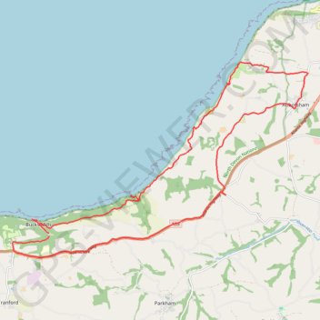
Bucks mills to Abbotsham
- Distance: 16.8 mi
- Elevation gain: 964 m
- Maximum elevation: 191 m
- Elevation loss: 951 m
- Minimum elevation: 0 m
- Moving time: 6 h 57 m
- Moving speed: 2.4 mph
- Maximum speed: 30.4 mph
- Total time: 8 h 1 m
- Global speed: 2.1 mph
Interactive trail map
Trail profile
- Distance: 16.8 mi
- Elevation gain: 964 m
- Maximum elevation: 191 m
- Elevation loss: 951 m
- Minimum elevation: 0 m
- Moving time: 6 h 57 m
- Moving speed: 2.4 mph
- Maximum speed: 30.4 mph
- Total time: 8 h 1 m
- Global speed: 2.1 mph
About this trail
Name: Bucks mills to Abbotsham trail, distance, elevation, map, profile, GPS track
Coordinates: 50.98003 -4.35500 51.02652 -4.24323
Topography: Torridge District topographic map, elevation, terrain
Other hiking, mountain biking, running and outdoor activity trails
Click on a trail to view its statistics, map and profile.
Northam Loop
United Kingdom > England > Devon > Torridge District > Abbotsham
Distance: 17.4 mi • Elevation gain: 447 m • Maximum elevation: 96 m