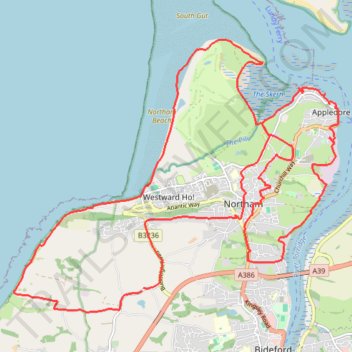
Northam Loop
- Distance: 17.4 mi
- Elevation gain: 447 m
- Maximum elevation: 96 m
- Elevation loss: 443 m
- Minimum elevation: 0 m
- Moving time: 7 h 5 m
- Moving speed: 2.5 mph
- Maximum speed: 6.0 mph
- Total time: 7 h 49 m
- Global speed: 2.2 mph
Interactive trail map
Trail profile
- Distance: 17.4 mi
- Elevation gain: 447 m
- Maximum elevation: 96 m
- Elevation loss: 443 m
- Minimum elevation: 0 m
- Moving time: 7 h 5 m
- Moving speed: 2.5 mph
- Maximum speed: 6.0 mph
- Total time: 7 h 49 m
- Global speed: 2.2 mph
About this trail
Name: Northam Loop trail, distance, elevation, map, profile, GPS track
Start: Abbotsham, Torridge District, Devon, England, EX39 5BE, United Kingdom (51.02696 -4.23779)
End: Abbotsham, Torridge District, Devon, England, EX39 5BE, United Kingdom (51.02736 -4.23735)
Coordinates: 51.02370 -4.26869 51.06483 -4.19057
Topography: Torridge District topographic map, elevation, terrain
Other hiking, mountain biking, running and outdoor activity trails
Click on a trail to view its statistics, map and profile.
Bucks mills to Abbotsham
United Kingdom > England > Devon > Torridge District > Bucks Mills
Distance: 16.8 mi • Elevation gain: 964 m • Maximum elevation: 191 m
Bideford Instow
United Kingdom > England > Devon > Torridge District > Northam
Distance: 16.5 mi • Elevation gain: 352 m • Maximum elevation: 86 m