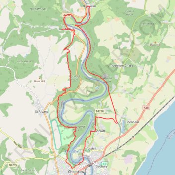
Tintern to Chepstow Loop Walk
- Distance: 15.0 mi
- Elevation gain: 691 m
- Maximum elevation: 222 m
- Elevation loss: 668 m
- Minimum elevation: -2 m
- Moving time: 5 h 12 m
- Moving speed: 2.9 mph
- Maximum speed: 6.3 mph
- Total time: 7 h 11 m
- Global speed: 2.1 mph
Interactive trail map
Trail profile
- Distance: 15.0 mi
- Elevation gain: 691 m
- Maximum elevation: 222 m
- Elevation loss: 668 m
- Minimum elevation: -2 m
- Moving time: 5 h 12 m
- Moving speed: 2.9 mph
- Maximum speed: 6.3 mph
- Total time: 7 h 11 m
- Global speed: 2.1 mph
About this trail
Name: Tintern to Chepstow Loop Walk trail, distance, elevation, map, profile, GPS track
Coordinates: 51.64210 -2.68883 51.70709 -2.64936
Topography: Monmouthshire topographic map, elevation, terrain
Other hiking, mountain biking, running and outdoor activity trails
Click on a trail to view its statistics, map and profile.
Tintern to Chepstow via Wye Valley Railway and Tidenham Tunnel
United Kingdom > England > Gloucestershire > Forest of Dean > Brockweir
Distance: 6.8 mi • Elevation gain: 219 m • Maximum elevation: 178 m
Tintern to Chepstow
United Kingdom > Wales > Monmouthshire > Tintern > Chapel Hill
Distance: 15.6 mi • Elevation gain: 729 m • Maximum elevation: 224 m
Dean2023-311
United Kingdom > England > Oxfordshire > Oxford
Distance: 192.8 mi • Elevation gain: 3,366 m • Maximum elevation: 290 m