Import a GPX file

Forest of Dean trails

Click on a trail to view its statistics, map and profile.

Tintern to Chepstow via Wye Valley Railway and Tidenham Tunnel

United Kingdom > England > Gloucestershire > Forest of Dean > Brockweir

Distance: 6.8 mi • Elevation gain: 219 m • Maximum elevation: 178 m
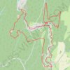
Forest of Dean Walking

United Kingdom > England > Gloucestershire > Forest of Dean > Upper Soudley > Lower Soudley

Distance: 10.4 mi • Elevation gain: 415 m • Maximum elevation: 227 m

Other places

 •

Gear up for your next adventure:

🗺️Topographic Maps - Detailed maps showing elevation and terrain features
🔥Emergency Fire Starters - Reliable ignition tools for survival situations in damp conditions
🧷Tenacious Repair Tape - Instant fix for torn tents, jackets, or dry bags
👟Women's Trail Running Shoes - Agile footwear for fell running and technical trails
💧Hydration Reservoirs - Convenient water bladders for hands-free drinking on the move

As an Amazon Associate, this site earns from qualifying purchases at no extra cost to you.