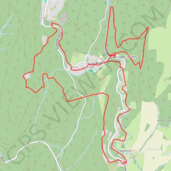
Forest of Dean Walking
- Distance: 10.4 mi
- Elevation gain: 415 m
- Maximum elevation: 227 m
- Elevation loss: 420 m
- Minimum elevation: 48 m
- Moving time: 4 h 1 m
- Moving speed: 2.6 mph
- Maximum speed: 22.4 mph
- Total time: 4 h 52 m
- Global speed: 2.1 mph
Interactive trail map
Trail profile
About this trail
Name: Forest of Dean Walking trail, distance, elevation, map, profile, GPS track
Coordinates: 51.77401 -2.51574 51.80212 -2.47971
Topography: Forest of Dean topographic map, elevation, terrain
Other hiking, mountain biking, running and outdoor activity trails
Click on a trail to view its statistics, map and profile.
Dean2023-311
United Kingdom > England > Oxfordshire > Oxford
Distance: 192.8 mi • Elevation gain: 3,366 m • Maximum elevation: 290 m