Thank you for supporting this site ❤️
Make a donation
Make a donation
Gear up for your next adventure:
As an Amazon Associate, this site earns from qualifying purchases at no extra cost to you.
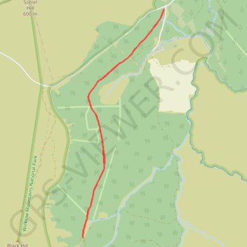
Walk to source of forest track
Ballydonnel North Track
- Distance: 3.9 mi
- Elevation gain: 128 m
- Maximum elevation: 424 m
- Elevation loss: 127 m
- Minimum elevation: 340 m
- Moving time: 55 m 30 s
- Moving speed: 4.2 mph
- Maximum speed: 4.5 mph
- Total time: 59 m 42 s
- Global speed: 3.9 mph
Interactive trail map
Thank you for supporting this site ❤️
Make a donation
Make a donation
Gear up for your next adventure:
As an Amazon Associate, this site earns from qualifying purchases at no extra cost to you.
Trail profile
- Distance: 3.9 mi
- Elevation gain: 128 m
- Maximum elevation: 424 m
- Elevation loss: 127 m
- Minimum elevation: 340 m
- Moving time: 55 m 30 s
- Moving speed: 4.2 mph
- Maximum speed: 4.5 mph
- Total time: 59 m 42 s
- Global speed: 3.9 mph
Thank you for supporting this site ❤️
Make a donation
Make a donation
Gear up for your next adventure:
As an Amazon Associate, this site earns from qualifying purchases at no extra cost to you.
About this trail
Name: Walk to source of forest track trail, distance, elevation, map, profile, GPS track
Coordinates: 53.12226 -6.43385 53.14627 -6.41957
Thank you for supporting this site ❤️
Make a donation
Make a donation
Gear up for your next adventure:
As an Amazon Associate, this site earns from qualifying purchases at no extra cost to you.
Other hiking, mountain biking, running and outdoor activity trails
Click on a trail to view its statistics, map and profile.
Mullaghcleevaun and Black Hill Loop
Wicklow Mountains National Park
Distance: 8.8 mi • Elevation gain: 564 m • Maximum elevation: 844 m