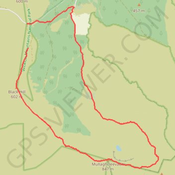
Mullaghcleevaun and Black Hill Loop
Wicklow Mountains National Park
- Distance: 8.8 mi
- Elevation gain: 564 m
- Maximum elevation: 844 m
- Elevation loss: 616 m
- Minimum elevation: 311 m
- Moving time: 3 h 12 m
- Moving speed: 2.7 mph
- Maximum speed: 4.5 mph
- Total time: 3 h 32 m
- Global speed: 2.5 mph
Interactive trail map
Trail profile
- Distance: 8.8 mi
- Elevation gain: 564 m
- Maximum elevation: 844 m
- Elevation loss: 616 m
- Minimum elevation: 311 m
- Moving time: 3 h 12 m
- Moving speed: 2.7 mph
- Maximum speed: 4.5 mph
- Total time: 3 h 32 m
- Global speed: 2.5 mph
About this trail
Name: Mullaghcleevaun and Black Hill Loop trail, distance, elevation, map, profile, GPS track
Coordinates: 53.10141 -6.44553 53.14263 -6.38510
Other hiking, mountain biking, running and outdoor activity trails
Click on a trail to view its statistics, map and profile.
Walk to source of forest track
Ireland > County Wicklow > Lacken
Ballydonnel North Track
Distance: 3.9 mi • Elevation gain: 128 m • Maximum elevation: 424 m