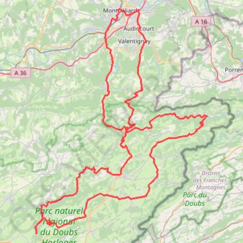
Parking Velotte, Montbéliard - Montbéliard
- Distance: 110.9 mi
- Elevation gain: 2,883 m
- Maximum elevation: 887 m
- Elevation loss: 2,883 m
- Minimum elevation: 311 m
Interactive trail map
Trail profile
- Distance: 110.9 mi
- Elevation gain: 2,883 m
- Maximum elevation: 887 m
- Elevation loss: 2,883 m
- Minimum elevation: 311 m
About this trail
Name: Parking Velotte, Montbéliard - Montbéliard trail, distance, elevation, map, profile, GPS track
Coordinates: 47.15787 6.60224 47.51188 7.00240
Other hiking, mountain biking, running and outdoor activity trails
Click on a trail to view its statistics, map and profile.
PT23DS2 Lörrach → Cadaqués
Germany > Baden-Württemberg > Landkreis Lörrach > Lörrach (Kernstadt)
Distance: 652.9 mi • Elevation gain: 13,130 m • Maximum elevation: 1,505 m
Riethoven naar Oostenrijk
Netherlands > North Brabant > Riethoven > Eind
Distance: 573.0 mi • Elevation gain: 13,629 m • Maximum elevation: 1,897 m