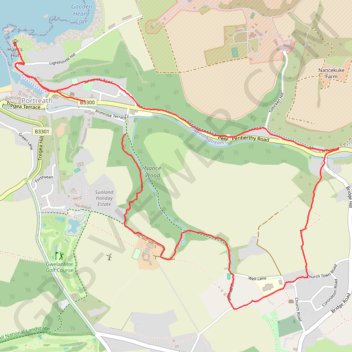
Portreath Walk
- Distance: 4.1 mi
- Elevation gain: 176 m
- Maximum elevation: 85 m
- Elevation loss: 191 m
- Minimum elevation: 1 m
- Moving time: 1 h 28 m
- Moving speed: 2.8 mph
- Maximum speed: 4.0 mph
- Total time: 1 h 39 m
- Global speed: 2.5 mph
Interactive trail map
Trail profile
- Distance: 4.1 mi
- Elevation gain: 176 m
- Maximum elevation: 85 m
- Elevation loss: 191 m
- Minimum elevation: 1 m
- Moving time: 1 h 28 m
- Moving speed: 2.8 mph
- Maximum speed: 4.0 mph
- Total time: 1 h 39 m
- Global speed: 2.5 mph
About this trail
Name: Portreath Walk trail, distance, elevation, map, profile, GPS track
Start: Primrose Terrace, Portreath, Cornwall, England, TR16 4JR, United Kingdom (50.25903 -5.28200)
End: Penberthy Road, Portreath, Cornwall, England, TR16 4LP, United Kingdom (50.26082 -5.28552)
Coordinates: 50.24942 -5.29169 50.26404 -5.26375
Topography: Cornwall topographic map, elevation, terrain
Other hiking, mountain biking, running and outdoor activity trails
Click on a trail to view its statistics, map and profile.
Portreath Oorthtowan Loop
United Kingdom > England > Cornwall > Portreath
Portreath, Oorthtowan
Distance: 14.1 mi • Elevation gain: 852 m • Maximum elevation: 103 m
Godrevy Point - Portreath
United Kingdom > England > Cornwall > Camborne > Gwealavellan
Distance: 13.1 mi • Elevation gain: 938 m • Maximum elevation: 91 m
Portreath to Porthtowan
United Kingdom > England > Cornwall > Portreath
Distance: 14.7 mi • Elevation gain: 942 m • Maximum elevation: 104 m
Redruth/Illogan Loop
United Kingdom > England > Cornwall > Redruth
Distance: 10.5 mi • Elevation gain: 197 m • Maximum elevation: 137 m