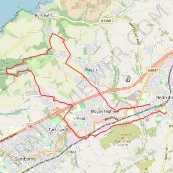
Redruth/Illogan Loop
- Distance: 10.5 mi
- Elevation gain: 197 m
- Maximum elevation: 137 m
- Elevation loss: 196 m
- Minimum elevation: 50 m
- Moving time: 15 m 48 s
- Moving speed: 39.9 mph
- Maximum speed: 32.8 mph
- Total time: 15 m 48 s
- Global speed: 39.9 mph
Interactive trail map
Trail profile
- Distance: 10.5 mi
- Elevation gain: 197 m
- Maximum elevation: 137 m
- Elevation loss: 196 m
- Minimum elevation: 50 m
- Moving time: 15 m 48 s
- Moving speed: 39.9 mph
- Maximum speed: 32.8 mph
- Total time: 15 m 48 s
- Global speed: 39.9 mph
About this trail
Name: Redruth/Illogan Loop trail, distance, elevation, map, profile, GPS track
End: 12, Gilly Fields, Redruth, Cornwall, England, TR15 2TF, United Kingdom (50.22907 -5.22659)
Coordinates: 50.22025 -5.30853 50.25479 -5.22659
Topography: Cornwall topographic map, elevation, terrain
Other hiking, mountain biking, running and outdoor activity trails
Click on a trail to view its statistics, map and profile.
Portreath Oorthtowan Loop
United Kingdom > England > Cornwall > Portreath
Portreath, Oorthtowan
Distance: 14.1 mi • Elevation gain: 852 m • Maximum elevation: 103 m
Godrevy Point - Portreath
United Kingdom > England > Cornwall > Camborne > Gwealavellan
Distance: 13.1 mi • Elevation gain: 938 m • Maximum elevation: 91 m
Bike trip to Bissoe
United Kingdom > England > Cornwall > Redruth
Cycle ride
Distance: 16.6 mi • Elevation gain: 378 m • Maximum elevation: 199 m
Portreath Walk
United Kingdom > England > Cornwall > Portreath
Distance: 4.1 mi • Elevation gain: 176 m • Maximum elevation: 85 m