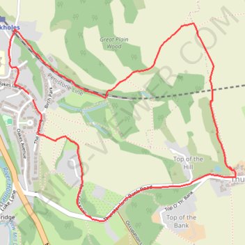
Brockholes and Thurstonland Loop
- Distance: 2.5 mi
- Elevation gain: 144 m
- Maximum elevation: 262 m
- Elevation loss: 141 m
- Minimum elevation: 134 m
- Moving time: 1 h 36 m
- Moving speed: 1.6 mph
- Maximum speed: 2.7 mph
- Total time: 1 h 59 m
- Global speed: 1.3 mph
Interactive trail map
Trail profile
- Distance: 2.5 mi
- Elevation gain: 144 m
- Maximum elevation: 262 m
- Elevation loss: 141 m
- Minimum elevation: 134 m
- Moving time: 1 h 36 m
- Moving speed: 1.6 mph
- Maximum speed: 2.7 mph
- Total time: 1 h 59 m
- Global speed: 1.3 mph
About this trail
Name: Brockholes and Thurstonland Loop trail, distance, elevation, map, profile, GPS track
Coordinates: 53.58812 -1.76931 53.59683 -1.75248
Topography: Kirklees topographic map, elevation, terrain
Other hiking, mountain biking, running and outdoor activity trails
Click on a trail to view its statistics, map and profile.
Brockholes woods explore
United Kingdom > England > Kirklees > Brockholes > Upper Hagg
Distance: 2.0 mi • Elevation gain: 128 m • Maximum elevation: 218 m
Brockholes woods explore
United Kingdom > England > Kirklees > Brockholes > Upper Hagg
Distance: 1.3 mi • Elevation gain: 78 m • Maximum elevation: 200 m
Gate Foot to Farnley Tyas via Thurstonland
United Kingdom > England > Kirklees > Kirkburton
Gate Foot - Snowgate Head - Fulstone - Biggin - Top of the Bank - Thurstonland - Top of the Hill - Farnley Tyas
Distance: 3.6 mi • Elevation gain: 142 m • Maximum elevation: 288 m