Brockholes woods explore
- Distance: 1.3 mi
- Elevation gain: 78 m
- Maximum elevation: 200 m
- Elevation loss: 78 m
- Minimum elevation: 145 m
- Moving time: 1 h 2 m
- Moving speed: 1.3 mph
- Maximum speed: 2.2 mph
- Total time: 1 h 33 m
- Global speed: 0.9 mph
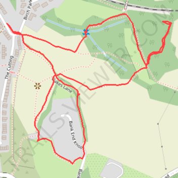
Interactive trail map
Trail profile
- Distance: 1.3 mi
- Elevation gain: 78 m
- Maximum elevation: 200 m
- Elevation loss: 78 m
- Minimum elevation: 145 m
- Moving time: 1 h 2 m
- Moving speed: 1.3 mph
- Maximum speed: 2.2 mph
- Total time: 1 h 33 m
- Global speed: 0.9 mph
About this trail
Name: Brockholes woods explore trail, distance, elevation, map, profile, GPS track
Coordinates: 53.58959 -1.76725 53.59345 -1.76011
Topography: Kirklees topographic map, elevation, terrain
Other hiking, mountain biking, running and outdoor activity trails
Click on a trail to view its statistics, map and profile.
Brockholes woods explore
United Kingdom > England > Kirklees > Brockholes > Upper Hagg
Distance: 2.0 mi • Elevation gain: 128 m • Maximum elevation: 218 m
Brockholes and Thurstonland Loop
United Kingdom > England > Kirklees > Brockholes > Upper Hagg
Distance: 2.5 mi • Elevation gain: 144 m • Maximum elevation: 262 m