Fort Snelling State Park Minnesota River Greenway Loop
- Distance: 9.9 mi
- Elevation gain: 118 m
- Maximum elevation: 252 m
- Elevation loss: 120 m
- Minimum elevation: 212 m
- Moving time: 1 h 42 m
- Moving speed: 5.8 mph
- Maximum speed: 13.7 mph
- Total time: 1 h 44 m
- Global speed: 5.7 mph
Interactive trail map
Trail profile
- Distance: 9.9 mi
- Elevation gain: 118 m
- Maximum elevation: 252 m
- Elevation loss: 120 m
- Minimum elevation: 212 m
- Moving time: 1 h 42 m
- Moving speed: 5.8 mph
- Maximum speed: 13.7 mph
- Total time: 1 h 44 m
- Global speed: 5.7 mph
About this trail
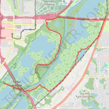
Name: Fort Snelling State Park Minnesota River Greenway Loop trail, distance, elevation, map, profile, GPS track
End: Mendota Trail, Eagan, Dakota County, Minnesota, 55425, United States (44.83542 -93.22282)
Coordinates: 44.82665 -93.24417 44.86233 -93.17634
Other hiking, mountain biking, running and outdoor activity trails
Click on a trail to view its statistics, map and profile.
Minnesota Valley National Wildlife Refuge Hiking - Bass Ponds to Old Cedar Ave bridge
United States > Minnesota > Hennepin County > Bloomington
Distance: 3.8 mi • Elevation gain: 63 m • Maximum elevation: 245 m
Bike Ride on Minnesota Valley State Trail
United States > Minnesota > Hennepin County > Bloomington
Distance: 11.6 mi • Elevation gain: 101 m • Maximum elevation: 247 m
Quarry Island
United States > Minnesota > Dakota County > Mendota Heights
Distance: 2.8 mi • Elevation gain: 58 m • Maximum elevation: 249 m