Quarry Island
- Distance: 2.8 mi
- Elevation gain: 58 m
- Maximum elevation: 249 m
- Elevation loss: 58 m
- Minimum elevation: 212 m
- Moving time: 1 h 8 m
- Moving speed: 2.5 mph
- Maximum speed: 4.0 mph
- Total time: 1 h 11 m
- Global speed: 2.4 mph
Interactive trail map
Trail profile
- Distance: 2.8 mi
- Elevation gain: 58 m
- Maximum elevation: 249 m
- Elevation loss: 58 m
- Minimum elevation: 212 m
- Moving time: 1 h 8 m
- Moving speed: 2.5 mph
- Maximum speed: 4.0 mph
- Total time: 1 h 11 m
- Global speed: 2.4 mph
About this trail
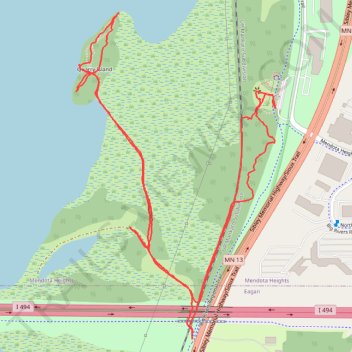
Name: Quarry Island trail, distance, elevation, map, profile, GPS track
Coordinates: 44.86044 -93.18135 44.86952 -93.17352
Other hiking, mountain biking, running and outdoor activity trails
Click on a trail to view its statistics, map and profile.
Fort Snelling State Park Minnesota River Greenway Loop
United States > Minnesota > Hennepin County > Bloomington
Distance: 9.9 mi • Elevation gain: 118 m • Maximum elevation: 252 m