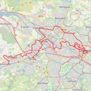
Johnstone, Scotland to Paisley via Glasgow
Bike
- Distance: 40.5 mi
- Elevation gain: 458 m
- Maximum elevation: 53 m
- Elevation loss: 468 m
- Minimum elevation: 0 m
- Moving time: 4 h 34 m
- Moving speed: 8.9 mph
- Maximum speed: 18.7 mph
- Total time: 5 h 51 m
- Global speed: 6.9 mph
Interactive trail map
Trail profile
- Distance: 40.5 mi
- Elevation gain: 458 m
- Maximum elevation: 53 m
- Elevation loss: 468 m
- Minimum elevation: 0 m
- Moving time: 4 h 34 m
- Moving speed: 8.9 mph
- Maximum speed: 18.7 mph
- Total time: 5 h 51 m
- Global speed: 6.9 mph
About this trail
Name: Johnstone, Scotland to Paisley via Glasgow trail, distance, elevation, map, profile, GPS track
Coordinates: 55.83446 -4.51848 55.90590 -4.24284
Topography: Renfrewshire topographic map, elevation, terrain
Other hiking, mountain biking, running and outdoor activity trails
Click on a trail to view its statistics, map and profile.
Roads and trails in Clydebank and Drumchapel
United Kingdom > Scotland > Glasgow City > Glasgow
Distance: 7.2 mi • Elevation gain: 97 m • Maximum elevation: 46 m
Walking trails along River Kelvin to Kelvin Aqueduct
United Kingdom > Scotland > Glasgow City > Glasgow
Distance: 1.6 mi • Elevation gain: 30 m • Maximum elevation: 40 m
Critical Mass Glasgow Loop Bike
United Kingdom > Scotland > Glasgow City > Glasgow
Distance: 8.1 mi • Elevation gain: 74 m • Maximum elevation: 29 m
Glasgow Queen's Park Walk
United Kingdom > Scotland > Glasgow City > Glasgow
Distance: 3.3 mi • Elevation gain: 68 m • Maximum elevation: 66 m
Glasgow, Scotland
United Kingdom > Scotland > Glasgow City > Glasgow
Afternoon Loop Bike Ride
Distance: 7.3 mi • Elevation gain: 150 m • Maximum elevation: 111 m
Critical Mass Glasgow
United Kingdom > Scotland > Glasgow City > Glasgow
Bike
Distance: 12.4 mi • Elevation gain: 150 m • Maximum elevation: 37 m
Critical Mass Glasgow
United Kingdom > Scotland > Glasgow City > Glasgow
Bike
Distance: 9.2 mi • Elevation gain: 102 m • Maximum elevation: 36 m
Govan-Partick Bridge
United Kingdom > Scotland > Glasgow City > Glasgow
Distance: 2.4 mi • Elevation gain: 37 m • Maximum elevation: 27 m
Glasgow, Scotland
United Kingdom > Scotland > Glasgow City > Glasgow
Morning Walk
Distance: 1.4 mi • Elevation gain: 27 m • Maximum elevation: 31 m