Make a donation
Gear up for your next adventure:
As an Amazon Associate, this site earns from qualifying purchases at no extra cost to you.
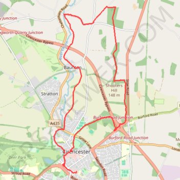
Cirencester, Baunton and Shooters Hill Loop
- Distance: 9.3 mi
- Elevation gain: 132 m
- Maximum elevation: 174 m
- Elevation loss: 137 m
- Minimum elevation: 111 m
- Moving time: 2 h 38 m
- Moving speed: 3.5 mph
- Maximum speed: 5.4 mph
- Total time: 3 h 29 m
- Global speed: 2.7 mph
Interactive trail map
Make a donation
Gear up for your next adventure:
As an Amazon Associate, this site earns from qualifying purchases at no extra cost to you.
Trail profile
- Distance: 9.3 mi
- Elevation gain: 132 m
- Maximum elevation: 174 m
- Elevation loss: 137 m
- Minimum elevation: 111 m
- Moving time: 2 h 38 m
- Moving speed: 3.5 mph
- Maximum speed: 5.4 mph
- Total time: 3 h 29 m
- Global speed: 2.7 mph
Make a donation
Gear up for your next adventure:
As an Amazon Associate, this site earns from qualifying purchases at no extra cost to you.
About this trail
Name: Cirencester, Baunton and Shooters Hill Loop trail, distance, elevation, map, profile, GPS track
Coordinates: 51.71131 -1.97563 51.75518 -1.94493
Topography: Cotswold District topographic map, elevation, terrain
Make a donation
Gear up for your next adventure:
As an Amazon Associate, this site earns from qualifying purchases at no extra cost to you.
Other hiking, mountain biking, running and outdoor activity trails
Click on a trail to view its statistics, map and profile.
Ciren Park Loop
United Kingdom > England > Gloucestershire > Cotswold District > Cirencester > Chesterton
Distance: 14.6 mi • Elevation gain: 176 m • Maximum elevation: 183 m
Baunton Cirencester
United Kingdom > England > Gloucestershire > Cotswold District > Cirencester > Chesterton
Distance: 14.5 mi • Elevation gain: 181 m • Maximum elevation: 174 m
Cirencester Dobbies
United Kingdom > England > Gloucestershire > Cotswold District > Cirencester > Chesterton
Distance: 6.1 mi • Elevation gain: 45 m • Maximum elevation: 117 m
Make a donation
Gear up for your next adventure:
As an Amazon Associate, this site earns from qualifying purchases at no extra cost to you.
Dean2023-311
United Kingdom > England > Oxfordshire > Oxford
Distance: 192.8 mi • Elevation gain: 3,366 m • Maximum elevation: 290 m
Cirencester north
United Kingdom > England > Gloucestershire > Cotswold District > Cirencester > Chesterton
Distance: 7.4 mi • Elevation gain: 118 m • Maximum elevation: 153 m
Cirencester Park
United Kingdom > England > Gloucestershire > Cotswold District > Cirencester > Chesterton
Distance: 10.0 mi • Elevation gain: 126 m • Maximum elevation: 184 m