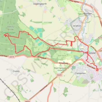
Cirencester Park Loop
Loop hike through the Cirencester Park in the Cotswolds National Landscape. #Hiking #Loop #Nature #Forest #Park
- Distance: 12.7 mi
- Elevation gain: 167 m
- Maximum elevation: 178 m
- Elevation loss: 166 m
- Minimum elevation: 107 m
- Moving time: 3 h 48 m
- Moving speed: 3.3 mph
- Maximum speed: 5.8 mph
- Total time: 4 h 31 m
- Global speed: 2.8 mph
Interactive trail map
Trail profile
- Distance: 12.7 mi
- Elevation gain: 167 m
- Maximum elevation: 178 m
- Elevation loss: 166 m
- Minimum elevation: 107 m
- Moving time: 3 h 48 m
- Moving speed: 3.3 mph
- Maximum speed: 5.8 mph
- Total time: 4 h 31 m
- Global speed: 2.8 mph
About this trail
Name: Cirencester Park Loop trail, distance, elevation, map, profile, GPS track
Coordinates: 51.70685 -2.04383 51.72928 -1.95818
Topography: Cotswold District topographic map, elevation, terrain
Other hiking, mountain biking, running and outdoor activity trails
Click on a trail to view its statistics, map and profile.
Baunton Cirencester
United Kingdom > England > Gloucestershire > Cotswold District > Cirencester > Chesterton
Distance: 14.5 mi • Elevation gain: 181 m • Maximum elevation: 174 m
Cirencester, Baunton and Shooters Hill Loop
United Kingdom > England > Gloucestershire > Cotswold District > Cirencester > Chesterton
Distance: 9.3 mi • Elevation gain: 132 m • Maximum elevation: 174 m
Thames Head Loop Hike
United Kingdom > England > Gloucestershire > Cotswold District > Cirencester > Chesterton
Distance: 12.5 mi • Elevation gain: 150 m • Maximum elevation: 165 m
Cirencester Dobbies
United Kingdom > England > Gloucestershire > Cotswold District > Cirencester > Chesterton
Distance: 6.1 mi • Elevation gain: 45 m • Maximum elevation: 117 m
Ciren Park Loop
United Kingdom > England > Gloucestershire > Cotswold District > Cirencester > Chesterton
Distance: 14.6 mi • Elevation gain: 176 m • Maximum elevation: 183 m
Dean2023-311
United Kingdom > England > Oxfordshire > Oxford
Distance: 192.8 mi • Elevation gain: 3,366 m • Maximum elevation: 290 m
Cirencester north
United Kingdom > England > Gloucestershire > Cotswold District > Cirencester > Chesterton
Distance: 7.4 mi • Elevation gain: 118 m • Maximum elevation: 153 m
Cirencester Park
United Kingdom > England > Gloucestershire > Cotswold District > Cirencester > Chesterton
Distance: 10.0 mi • Elevation gain: 126 m • Maximum elevation: 184 m