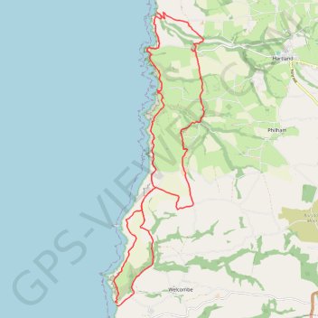
Welcombe to Hartland Loop
Loop hike from Welcombe to Hartland via Dyer's Lookout, Blackpool, St Nectan's Church, Stoke, Milford, Elmscott, Hardisworthy and South Hole in the North Devon National Landscape. #Hiking #Loop #Coast #Sea #Atlantic #Ocean #Nature #Countryside #Cliffs #Overlook
- Distance: 15.6 mi
- Elevation gain: 841 m
- Maximum elevation: 166 m
- Elevation loss: 849 m
- Minimum elevation: 3 m
- Moving time: 6 h 24 m
- Moving speed: 2.4 mph
- Maximum speed: 15.6 mph
- Total time: 7 h 20 m
- Global speed: 2.1 mph
Interactive trail map
Trail profile
- Distance: 15.6 mi
- Elevation gain: 841 m
- Maximum elevation: 166 m
- Elevation loss: 849 m
- Minimum elevation: 3 m
- Moving time: 6 h 24 m
- Moving speed: 2.4 mph
- Maximum speed: 15.6 mph
- Total time: 7 h 20 m
- Global speed: 2.1 mph
About this trail
Name: Welcombe to Hartland Loop trail, distance, elevation, map, profile, GPS track
Coordinates: 50.93335 -4.54609 51.00360 -4.51199
Topography: Torridge District topographic map, elevation, terrain
Other hiking, mountain biking, running and outdoor activity trails
Click on a trail to view its statistics, map and profile.
Stoke hartland
United Kingdom > England > Devon > Torridge District > Hartland > Stoke
Distance: 11.2 mi • Elevation gain: 629 m • Maximum elevation: 149 m