Make a donation
Gear up for your next adventure:
As an Amazon Associate, this site earns from qualifying purchases at no extra cost to you.
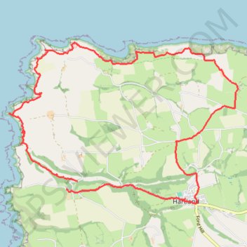
Stoke hartland
- Distance: 11.2 mi
- Elevation gain: 629 m
- Maximum elevation: 149 m
- Elevation loss: 589 m
- Minimum elevation: 0 m
- Moving time: 4 h 50 m
- Moving speed: 2.3 mph
- Maximum speed: 28.7 mph
- Total time: 5 h 47 m
- Global speed: 1.9 mph
Interactive trail map
Make a donation
Gear up for your next adventure:
As an Amazon Associate, this site earns from qualifying purchases at no extra cost to you.
Trail profile
- Distance: 11.2 mi
- Elevation gain: 629 m
- Maximum elevation: 149 m
- Elevation loss: 589 m
- Minimum elevation: 0 m
- Moving time: 4 h 50 m
- Moving speed: 2.3 mph
- Maximum speed: 28.7 mph
- Total time: 5 h 47 m
- Global speed: 1.9 mph
Make a donation
Gear up for your next adventure:
As an Amazon Associate, this site earns from qualifying purchases at no extra cost to you.
About this trail
Name: Stoke hartland trail, distance, elevation, map, profile, GPS track
Start: Stoke, Hartland, Torridge District, Devon, England, EX39 6DU, United Kingdom (50.99621 -4.51379)
Coordinates: 50.99197 -4.53365 51.02159 -4.46708
Topography: Torridge District topographic map, elevation, terrain
Make a donation
Gear up for your next adventure:
As an Amazon Associate, this site earns from qualifying purchases at no extra cost to you.
Other hiking, mountain biking, running and outdoor activity trails
Click on a trail to view its statistics, map and profile.
Welcombe to Hartland Loop
United Kingdom > England > Devon > Torridge District > Welcombe > Mead
Loop hike from Welcombe to Hartland via Dyer's Lookout, Blackpool, St Nectan's Church, Stoke, Milford, Elmscott, Hardisworthy and South Hole in the North Devon National Landscape. #Hiking #Loop #Coast #Sea #Atlantic #Ocean #Nature #Countryside #Cliffs #Overlook
Distance: 15.6 mi • Elevation gain: 841 m • Maximum elevation: 166 m