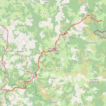
LeSauvageAumontAubrac
Etape 4 du Chemin de Saint Jacques de Compostelle
- Distance: 17.5 mi
- Elevation gain: 503 m
- Maximum elevation: 1,326 m
- Elevation loss: 748 m
- Minimum elevation: 918 m
Interactive trail map
Trail profile
- Distance: 17.5 mi
- Elevation gain: 503 m
- Maximum elevation: 1,326 m
- Elevation loss: 748 m
- Minimum elevation: 918 m
About this trail
Name: LeSauvageAumontAubrac trail, distance, elevation, map, profile, GPS track
Coordinates: 44.72019 3.28627 44.83182 3.48765
Other hiking, mountain biking, running and outdoor activity trails
Click on a trail to view its statistics, map and profile.
PT23DS2 Lörrach → Cadaqués
Germany > Baden-Württemberg > Landkreis Lörrach > Lörrach (Kernstadt)
Distance: 652.9 mi • Elevation gain: 13,130 m • Maximum elevation: 1,505 m
Southern section — European Divide Trail
France > Auvergne-Rhône-Alpes > Drôme > Valence
Distance: 1,506.1 mi • Elevation gain: 42,375 m • Maximum elevation: 2,005 m
Chemin de Saint-Jacques-de-Compostelle
Switzerland > Geneva > Geneva
Distance: 694.6 mi • Elevation gain: 25,262 m • Maximum elevation: 1,430 m