Import a GPX file

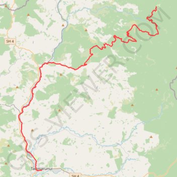
Piropiro - Taumarunui

Pureora Forest. Ongarue River. #Bike #MTB #Countryside #Forest #River #Nature

  • Distance: 42.8 mi
  • Elevation gain: 1,050 m
  • Maximum elevation: 628 m
  • Elevation loss: 1,316 m
  • Minimum elevation: 167 m

Interactive trail map

Trail profile

  • Distance: 42.8 mi
  • Elevation gain: 1,050 m
  • Maximum elevation: 628 m
  • Elevation loss: 1,316 m
  • Minimum elevation: 167 m

About this trail

Other hiking, mountain biking, running and outdoor activity trails

Click on a trail to view its statistics, map and profile.

Taumarunui - Owhango

New Zealand > Manawatū-Whanganui > Ruapehu District

Whanganui River. #Bike #Road #River #Forest #Mountain #Nature

Distance: 17.4 mi • Elevation gain: 737 m • Maximum elevation: 488 m

Mangakino - Piropiro

New Zealand > Waikato > Taupo District > Mangakino

#Bike #Maraetai #Waikato

Distance: 51.3 mi • Elevation gain: 1,893 m • Maximum elevation: 995 m

Gear up for your next adventure:

Insulated Travel Mugs - Keep drinks hot while surveying the landscape from a summit
👟Women's Trail Running Shoes - Agile footwear for fell running and technical trails
🗺️Scratch-off Peak Maps - Track your progress climbing Munros or Wainwrights
📱Rugged Phone Cases - Heavy-duty protection for smartphones used as secondary GPS tools
GPS Outdoor Watches - Watches with GPS tracking for hiking and exploration

As an Amazon Associate, this site earns from qualifying purchases at no extra cost to you.