Import a GPX file

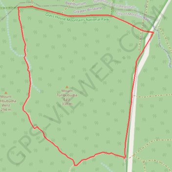
Mount Tunbubudla Circuit

Glass House Mountains National Park. #Hiking #Loop #GlassHouse

  • Distance: 3.7 mi
  • Elevation gain: 107 m
  • Maximum elevation: 111 m
  • Elevation loss: 108 m
  • Minimum elevation: 35 m

Interactive trail map

Trail profile

  • Distance: 3.7 mi
  • Elevation gain: 107 m
  • Maximum elevation: 111 m
  • Elevation loss: 108 m
  • Minimum elevation: 35 m

About this trail
Other hiking, mountain biking, running and outdoor activity trails

Click on a trail to view its statistics, map and profile.
Beerburrum - Woodford - Glass House Moutains

Australia > Queensland > Sunshine Coast Regional

#MTB #Loop

Distance: 41.8 mi • Elevation gain: 955 m • Maximum elevation: 212 m

Lake Somerset - Beerburrum

Australia > Queensland

#Bike #Somerset

Distance: 37.5 mi • Elevation gain: 543 m • Maximum elevation: 176 m

Gear up for your next adventure:

🛌Insulated Sleeping Mats - Crucial thermal protection when sleeping on cold, uneven ground
⛺Lightweight Tents - Compact tents for backpacking and trekking
🧘Folding Sit Mats - Dry and warm seat for map-reading breaks on damp ground
🧴Sport Sunscreen Sticks - High-protection sunblock that won't run into your eyes on the trail
🥾Walking Shoes - Lightweight walking shoes for countryside and coastal paths

As an Amazon Associate, this site earns from qualifying purchases at no extra cost to you.