Make a donation
Gear up for your next adventure:
As an Amazon Associate, this site earns from qualifying purchases at no extra cost to you.
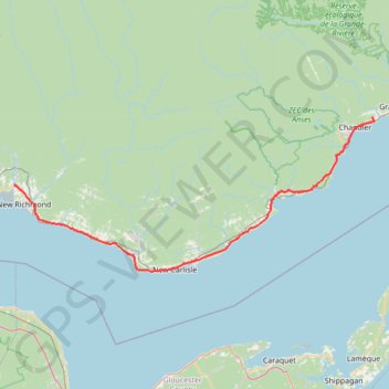
Saint-François-de-Pabos - New Richmond
Gulf of Saint Lawrence. #Bike #SaintFrançoisDePabos #NewRichmond #SaintLawrence #Atlantic
- Distance: 79.1 mi
- Elevation gain: 929 m
- Maximum elevation: 97 m
- Elevation loss: 928 m
- Minimum elevation: -1 m
Interactive trail map
Make a donation
Gear up for your next adventure:
As an Amazon Associate, this site earns from qualifying purchases at no extra cost to you.
Trail profile
- Distance: 79.1 mi
- Elevation gain: 929 m
- Maximum elevation: 97 m
- Elevation loss: 928 m
- Minimum elevation: -1 m
Make a donation
Gear up for your next adventure:
As an Amazon Associate, this site earns from qualifying purchases at no extra cost to you.
About this trail
Name: Saint-François-de-Pabos - New Richmond trail, distance, elevation, map, profile, GPS track
Coordinates: 48.00237 -65.89930 48.37136 -64.60886
Make a donation
Gear up for your next adventure:
As an Amazon Associate, this site earns from qualifying purchases at no extra cost to you.
Other hiking, mountain biking, running and outdoor activity trails
Click on a trail to view its statistics, map and profile.
Saint-Georges-de-Malbaie - Saint-François-de-Pabos
Canada > Quebec > Le Rocher-Percé > Percé > Saint-Georges-de-Malbaie > Pointe-Saint-Pierre
Gulf of Saint Lawrence. #Bike #SaintLawrence #Atlantic
Distance: 42.7 mi • Elevation gain: 700 m • Maximum elevation: 142 m
Campbellton - Bathurst
Canada > Quebec > Avignon > Pointe-à-la-Croix > Cross Point Station
Ristigouche River. Gulf of Saint Lawrence. #Bike #Campbellton #Bathurst #Ristigouche #SaintLawrence
Distance: 74.0 mi • Elevation gain: 668 m • Maximum elevation: 69 m