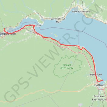
Campbellton - Bathurst
Ristigouche River. Gulf of Saint Lawrence. #Bike #Campbellton #Bathurst #Ristigouche #SaintLawrence
- Distance: 74.0 mi
- Elevation gain: 668 m
- Maximum elevation: 69 m
- Elevation loss: 676 m
- Minimum elevation: -1 m
Interactive trail map
Trail profile
- Distance: 74.0 mi
- Elevation gain: 668 m
- Maximum elevation: 69 m
- Elevation loss: 676 m
- Minimum elevation: -1 m
About this trail
Name: Campbellton - Bathurst trail, distance, elevation, map, profile, GPS track
Coordinates: 47.65024 -66.70446 48.06583 -65.62527
Other hiking, mountain biking, running and outdoor activity trails
Click on a trail to view its statistics, map and profile.
Saint-François-de-Pabos - New Richmond
Canada > Quebec > Le Rocher-Percé > Chandler > Pabos
Gulf of Saint Lawrence. #Bike #SaintFrançoisDePabos #NewRichmond #SaintLawrence #Atlantic
Distance: 79.1 mi • Elevation gain: 929 m • Maximum elevation: 97 m
New Richmond - Campbellton
Canada > Quebec > Bonaventure (MRC) > New Richmond
Ristigouche River. Gulf of Saint Lawrence. #Bike #SaintLawrence
Distance: 46.3 mi • Elevation gain: 475 m • Maximum elevation: 58 m
Bathurst - Black River Bridge
Canada > New Brunswick > Bathurst Parish > Bathurst
#Bike #Bathurst #BlackRiverBridge
Distance: 62.1 mi • Elevation gain: 656 m • Maximum elevation: 163 m
Causapscal - Campbellton
Canada > Quebec > La Matapédia > Causapscal
#Bike #Causapscal #Campbellton
Distance: 49.5 mi • Elevation gain: 680 m • Maximum elevation: 169 m