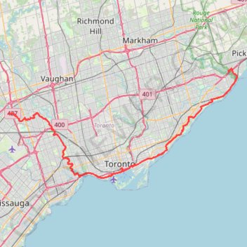
Brampton - Scarborough
Lake Ontario. #Bike #Brampton #Scarborough #Toronto #Ontario
- Distance: 45.5 mi
- Elevation gain: 570 m
- Maximum elevation: 184 m
- Elevation loss: 653 m
- Minimum elevation: 73 m
Interactive trail map
Trail profile
- Distance: 45.5 mi
- Elevation gain: 570 m
- Maximum elevation: 184 m
- Elevation loss: 653 m
- Minimum elevation: 73 m
About this trail
Name: Brampton - Scarborough trail, distance, elevation, map, profile, GPS track
Coordinates: 43.62986 -79.63545 43.80958 -79.11634
Other hiking, mountain biking, running and outdoor activity trails
Click on a trail to view its statistics, map and profile.
Old mills to humber bay park
Distance: 7.7 mi • Elevation gain: 75 m • Maximum elevation: 96 m
Biidaasige Park and Tommy Thompson Park Loop Ride
Distance: 12.7 mi • Elevation gain: 67 m • Maximum elevation: 82 m
Downtown Toronto Walk
Distance: 2.7 mi • Elevation gain: 140 m • Maximum elevation: 114 m
Scarborough - Cobourg
Lake Ontario. #Bike #Scarborough #Cobourg #Toronto #Ontario
Distance: 66.7 mi • Elevation gain: 717 m • Maximum elevation: 130 m
Toronto - Oshawa
Canada > Ontario > Old Toronto
#Bike
Distance: 41.8 mi • Elevation gain: 457 m • Maximum elevation: 183 m
Orangeville - Brampton
Canada > Ontario > Dufferin County > Mono
Distance: 34.1 mi • Elevation gain: 206 m • Maximum elevation: 461 m
Hamilton - Toronto
#Bike
Distance: 50.5 mi • Elevation gain: 458 m • Maximum elevation: 111 m
Serena Gundy Park
Distance: 0.8 mi • Elevation gain: 29 m • Maximum elevation: 129 m
Ontario country roads
Distance: 93.4 mi • Elevation gain: 1,137 m • Maximum elevation: 497 m
Toronto Cycling
Distance: 24.3 mi • Elevation gain: 356 m • Maximum elevation: 124 m
The Meadoway: Midland to Marcos section
Distance: 0.9 mi • Elevation gain: 4 m • Maximum elevation: 162 m