Make a donation
Gear up for your next adventure:
As an Amazon Associate, this site earns from qualifying purchases at no extra cost to you.
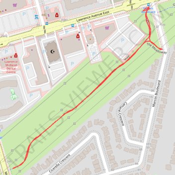
The Meadoway: Midland to Marcos section
- Distance: 0.9 mi
- Elevation gain: 4 m
- Maximum elevation: 162 m
- Elevation loss: 4 m
- Minimum elevation: 158 m
- Moving time: 7 m 17 s
- Moving speed: 7.5 mph
- Maximum speed: 34.4 mph
- Total time: 10 m 59 s
- Global speed: 5.0 mph
Interactive trail map
Make a donation
Gear up for your next adventure:
As an Amazon Associate, this site earns from qualifying purchases at no extra cost to you.
Trail profile
- Distance: 0.9 mi
- Elevation gain: 4 m
- Maximum elevation: 162 m
- Elevation loss: 4 m
- Minimum elevation: 158 m
- Moving time: 7 m 17 s
- Moving speed: 7.5 mph
- Maximum speed: 34.4 mph
- Total time: 10 m 59 s
- Global speed: 5.0 mph
Make a donation
Gear up for your next adventure:
As an Amazon Associate, this site earns from qualifying purchases at no extra cost to you.
About this trail
Name: The Meadoway: Midland to Marcos section trail, distance, elevation, map, profile, GPS track
Coordinates: 43.74838 -79.26362 43.75267 -79.25813
Make a donation
Gear up for your next adventure:
As an Amazon Associate, this site earns from qualifying purchases at no extra cost to you.
Other hiking, mountain biking, running and outdoor activity trails
Click on a trail to view its statistics, map and profile.
Toronto - Oshawa
Canada > Ontario > Old Toronto
#Bike
Distance: 41.8 mi • Elevation gain: 457 m • Maximum elevation: 183 m
Brampton - Scarborough
Canada > Ontario > Peel Region > Brampton
Lake Ontario. #Bike #Brampton #Scarborough #Toronto #Ontario
Distance: 45.5 mi • Elevation gain: 570 m • Maximum elevation: 184 m