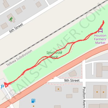
Steelhead Park
- Distance: 0.4 mi
- Elevation gain: 2 m
- Maximum elevation: 596 m
- Elevation loss: 2 m
- Minimum elevation: 594 m
- Moving time: 7 m 30 s
- Moving speed: 3.0 mph
- Maximum speed: 4.0 mph
- Total time: 9 m 58 s
- Global speed: 2.3 mph
Interactive trail map
Trail profile
- Distance: 0.4 mi
- Elevation gain: 2 m
- Maximum elevation: 596 m
- Elevation loss: 2 m
- Minimum elevation: 594 m
- Moving time: 7 m 30 s
- Moving speed: 3.0 mph
- Maximum speed: 4.0 mph
- Total time: 9 m 58 s
- Global speed: 2.3 mph
About this trail
Name: Steelhead Park trail, distance, elevation, map, profile, GPS track
Coordinates: 54.40021 -126.64931 54.40158 -126.64578
Other hiking, mountain biking, running and outdoor activity trails
Click on a trail to view its statistics, map and profile.