Geocaching at Bodega Bay Head Trail
- Distance: 1.8 mi
- Elevation gain: 62 m
- Maximum elevation: 41 m
- Elevation loss: 70 m
- Minimum elevation: 4 m
- Moving time: 47 m 7 s
- Moving speed: 2.3 mph
- Maximum speed: 3.8 mph
- Total time: 1 h 6 m
- Global speed: 1.6 mph
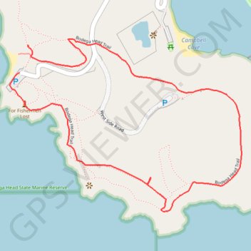
Interactive trail map
Trail profile
- Distance: 1.8 mi
- Elevation gain: 62 m
- Maximum elevation: 41 m
- Elevation loss: 70 m
- Minimum elevation: 4 m
- Moving time: 47 m 7 s
- Moving speed: 2.3 mph
- Maximum speed: 3.8 mph
- Total time: 1 h 6 m
- Global speed: 1.6 mph
About this trail
Name: Geocaching at Bodega Bay Head Trail trail, distance, elevation, map, profile, GPS track
Start: Overlook Trail, Sonoma County, California, 94923, United States (38.30479 -123.06401)
End: Bodega Head Trail, Sonoma County, California, 94923, United States (38.30389 -123.06439)
Coordinates: 38.29906 -123.06483 38.30505 -123.05455
Other hiking, mountain biking, running and outdoor activity trails
Click on a trail to view its statistics, map and profile.
Jetty hike and drive back
United States > California > Sonoma County
Bodega Bay
Distance: 6.7 mi • Elevation gain: 102 m • Maximum elevation: 41 m