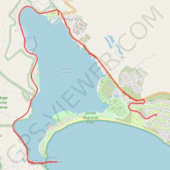
Jetty hike and drive back
Bodega Bay
- Distance: 6.7 mi
- Elevation gain: 102 m
- Maximum elevation: 41 m
- Elevation loss: 64 m
- Minimum elevation: -2 m
- Moving time: 52 m 46 s
- Moving speed: 7.6 mph
- Maximum speed: 45.6 mph
- Total time: 1 h 54 m
- Global speed: 3.5 mph
Interactive trail map
Trail profile
- Distance: 6.7 mi
- Elevation gain: 102 m
- Maximum elevation: 41 m
- Elevation loss: 64 m
- Minimum elevation: -2 m
- Moving time: 52 m 46 s
- Moving speed: 7.6 mph
- Maximum speed: 45.6 mph
- Total time: 1 h 54 m
- Global speed: 3.5 mph
About this trail
Name: Jetty hike and drive back trail, distance, elevation, map, profile, GPS track
Start: West Shore Road, Sonoma County, California, 94923, United States (38.30513 -123.05779)
Coordinates: 38.30461 -123.06172 38.33654 -123.02444
Other hiking, mountain biking, running and outdoor activity trails
Click on a trail to view its statistics, map and profile.
Geocaching at Bodega Bay Head Trail
United States > California > Sonoma County
Distance: 1.8 mi • Elevation gain: 62 m • Maximum elevation: 41 m