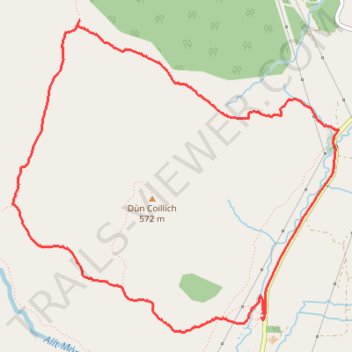
Dùn Coillich Loop
- Distance: 4.2 mi
- Elevation gain: 223 m
- Maximum elevation: 471 m
- Elevation loss: 225 m
- Minimum elevation: 290 m
- Moving time: 1 h 58 m
- Moving speed: 2.1 mph
- Maximum speed: 5.2 mph
- Total time: 2 h 12 m
- Global speed: 1.9 mph
Interactive trail map
Trail profile
- Distance: 4.2 mi
- Elevation gain: 223 m
- Maximum elevation: 471 m
- Elevation loss: 225 m
- Minimum elevation: 290 m
- Moving time: 1 h 58 m
- Moving speed: 2.1 mph
- Maximum speed: 5.2 mph
- Total time: 2 h 12 m
- Global speed: 1.9 mph
About this trail
Name: Dùn Coillich Loop trail, distance, elevation, map, profile, GPS track
Start: B846, Coshieville, Perth and Kinross, Scotland, PH15 2LG, United Kingdom (56.65178 -4.00957)
End: B846, Coshieville, Perth and Kinross, Scotland, PH15 2LG, United Kingdom (56.65157 -4.00964)
Coordinates: 56.65077 -4.03393 56.66752 -4.00216
Topography: Perth and Kinross topographic map, elevation, terrain
Other hiking, mountain biking, running and outdoor activity trails
Click on a trail to view its statistics, map and profile.
Walking Paths at Dùn Coillich
United Kingdom > Scotland > Perth and Kinross > Coshieville
Distance: 3.7 mi • Elevation gain: 211 m • Maximum elevation: 450 m