Make a donation
Gear up for your next adventure:
As an Amazon Associate, this site earns from qualifying purchases at no extra cost to you.
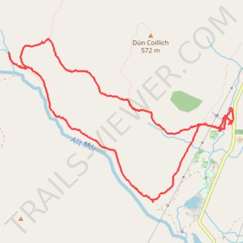
Walking Paths at Dùn Coillich
- Distance: 3.7 mi
- Elevation gain: 211 m
- Maximum elevation: 450 m
- Elevation loss: 208 m
- Minimum elevation: 289 m
- Moving time: 1 h 35 m
- Moving speed: 2.3 mph
- Maximum speed: 5.7 mph
- Total time: 1 h 46 m
- Global speed: 2.1 mph
Interactive trail map
Make a donation
Gear up for your next adventure:
As an Amazon Associate, this site earns from qualifying purchases at no extra cost to you.
Trail profile
- Distance: 3.7 mi
- Elevation gain: 211 m
- Maximum elevation: 450 m
- Elevation loss: 208 m
- Minimum elevation: 289 m
- Moving time: 1 h 35 m
- Moving speed: 2.3 mph
- Maximum speed: 5.7 mph
- Total time: 1 h 46 m
- Global speed: 2.1 mph
Make a donation
Gear up for your next adventure:
As an Amazon Associate, this site earns from qualifying purchases at no extra cost to you.
About this trail
Name: Walking Paths at Dùn Coillich trail, distance, elevation, map, profile, GPS track
Start: B846, Coshieville, Perth and Kinross, Scotland, PH15 2LG, United Kingdom (56.65175 -4.00985)
End: B846, Coshieville, Perth and Kinross, Scotland, PH15 2LG, United Kingdom (56.65170 -4.00960)
Coordinates: 56.64575 -4.03912 56.65762 -4.00944
Topography: Perth and Kinross topographic map, elevation, terrain
Make a donation
Gear up for your next adventure:
As an Amazon Associate, this site earns from qualifying purchases at no extra cost to you.
Other hiking, mountain biking, running and outdoor activity trails
Click on a trail to view its statistics, map and profile.
Dùn Coillich Loop
United Kingdom > Scotland > Perth and Kinross > Coshieville
Distance: 4.2 mi • Elevation gain: 223 m • Maximum elevation: 471 m