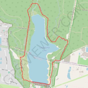
Lysterfield Lake Loop
Lysterfield Park. #Hiking #Loop #Lysterfield
- Distance: 3.8 mi
- Elevation gain: 92 m
- Maximum elevation: 105 m
- Elevation loss: 92 m
- Minimum elevation: 62 m
- Moving time: 1 h 2 m
- Moving speed: 3.7 mph
- Maximum speed: 12.6 mph
- Total time: 1 h 2 m
- Global speed: 3.7 mph
Interactive trail map
Trail profile
- Distance: 3.8 mi
- Elevation gain: 92 m
- Maximum elevation: 105 m
- Elevation loss: 92 m
- Minimum elevation: 62 m
- Moving time: 1 h 2 m
- Moving speed: 3.7 mph
- Maximum speed: 12.6 mph
- Total time: 1 h 2 m
- Global speed: 3.7 mph
About this trail
Name: Lysterfield Lake Loop trail, distance, elevation, map, profile, GPS track
Coordinates: -37.97125 145.29218 -37.95287 145.30581
Other hiking, mountain biking, running and outdoor activity trails
Click on a trail to view its statistics, map and profile.
Lysterfield Park MTB Loop
Australia > Victoria > Melbourne
#MTB #Loop #Lysterfield
Distance: 10.3 mi • Elevation gain: 380 m • Maximum elevation: 208 m
Lysterfield Lake Loop
Australia > Victoria > Melbourne
Lysterfield Park. #Hiking #Loop #Lysterfield
Distance: 3.6 mi • Elevation gain: 83 m • Maximum elevation: 101 m
Upwey - Lysterfield Lake
Australia > Victoria > Melbourne
Distance: 15.2 mi • Elevation gain: 735 m • Maximum elevation: 211 m
Lysterfield Park
Australia > Victoria > Melbourne
Distance: 4.2 mi • Elevation gain: 209 m • Maximum elevation: 201 m